

DMAB
-
Posts
259 -
Joined
Content Type
Forums
Store
Blogs
Downloads
Events
Gallery
Posts posted by DMAB
-
-
I am scheduled to cruise in April on the Star, this will be my first cruise with NCL but my 5th cruise all together. My question is how many cruisers actually lock up their luggage before embarking? I never have and haven't lost anything but I was just wondering if we should? Or if the cruise lines prefer you not to?
I lock mine with a cheap TSA approved lock. It doesn't make my bag thief proof, but it does make the unlocked bag next to it more attractive to the thief.
It don't care what the cruise lines prefer. The security droids can either use a TSA master key to open the lock, cut it off or call me. After years of using the locks I have never been called and only had one lock cut off (not by a cruise line).
-
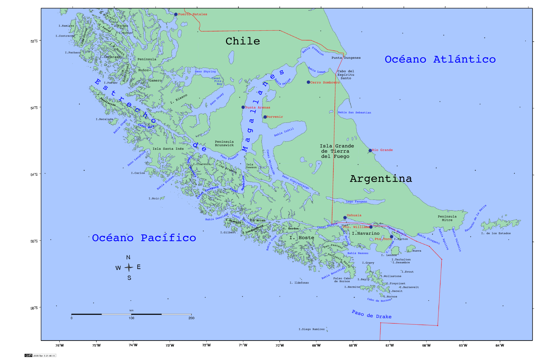
The map is great - and it DOES show Cockburn - west (to the left) of Madgelana.
We entered Bahia Desolata to enter Beagle Channel via the left hand side of Isle O'Brien (remember we were going from Valpa to BA).
I am a real map buff like you!
Hope you understand what I was talking about the Cape Horn islands, but the google map isn't marking the island next to on the left of Deceit as Herschel, and there is a narrow passage between these 2 isles where Sun sails thru.
I have found a really good map of the channels and fjords. This is a repeat of what I just posted in thge 31 Jan 2010 Sun Roll Call Forum. I'm puttng it here because I think it is of general interest for anyone going around the horn.
I mention two maps, the first one I mention is by far the best from a marine viewpoint. It clearly shows the route between Deceit and Hershel, it's even marked as a ship route.
I just got the following map from Amazon for $9.95. I'm sure it's available from other sources too.Patagonian & Fuegian Channels Map: Chilean Fjords Cruise Chart - Cape Horn, Ushuaia, Magellan Strait (Map)
~ Sergio Zagier (Author)
It's printed on heavy, slick paper stock, 27" x 38" open and folds down to about 5"x10"
Covers the Argentina Coast from about 100 miles North of the Straight of Magellan south and the Chilean Coast up to about 120 miles north of Puerto Chacabuco.. Latitude and Longitude are maked on the edges of the main map at 10 minute intervals and finer intervals on the detailed inset maps.
The Beagle Channel are shown in good detail in insets that total 30 inches in length.
I plan to use the map along with a hand held GPS that doesn't have built in detailed maps of the area to track where we are while I'm on deck gawking at the scenery.
=======================
I also found another reasonably good map that doesn't show the fjords and channels in as much detail but shows the land of Patagonia better. Also from Amazon but for $12.95.
South American Explorer: Visitor's Map of Southern Chile and Argentina Including the Chilean Fjords [FOLDED MAP] (Map)
~ Nigel Sitwell (Author)
I would say the fjord and channel detail is adequate, but not nearly as good as the first map I mentioned. This map has lat and long markings but only at 5 degree intervals. It also clearly shows lighthouse locations and the more detailed map above doesn't.
-
After Valparaiso it was Pacific Ocean for the night, full day and another night until we got into the Chilean fjords to Puerto Montt. Then it was still in the fjords to Puerto Chacabucco.
After that it was back into the Pacific Ocean for the night. Then back into the fjords for a bit and then back out into the ocean once again. The day before Puerto Arenas we got out of ocean into the Magellan Strait and stayed on course to Punta Arenas. Then it's southward (overnight) to the Magdalena Channel and west along Cockburn Channel until we reach the Antarctic ocean - sailed there for a bit until it's time to enter the fjords again to reach the Beagle Channel that led us to Ushuaia.
Thank you for the directions, the Cockburn channel didn't show on my map so I Googled and found this
http://upload.wikimedia.org/wikipedia/commons/a/ab/Chile.estrechodemagallanes.png
It's a nice detailed chart of the area.
Thanks again for the best description of the route I have seen!
-
If you have any Q’s do not hesitate to ask!
Can you describe the route the ship took down the coast of Chile to Pta Arenas and onto Ushuaia and the Horn. We will be going the other direction starting Jan 31st.
How many laundry by the bag specials did they have and was it possible to do more than one bag on the special day?
To lock your luggage or not
in Norwegian Cruise Line
Posted
I have a couple of suggestions.
Anyone who wants to lock their luggage should lock it.
Anyone who doen;t want to lock their luggage shouldn't lock it. If you don't lock your luggage, please try and place it near mine so that yours is a more attractive target than mine.